Autodesk Civil Training on the Web
Useful Civil Training Videos from YouTube and elsewhere
Framework Videos
Framework for Civil 3D Training
Site Access
Become a Site Member
Civil Videos
Free Curated Civil 3D Training
- See the AEC Webinars page.
See the page for up-coming Civil webinar signups. - See the AEC Tech Drop page and blogs
- Free Autodesk Civil 3D Certification Exam Courseware
- Autodesk University Online 2023
- Autodesk Customer Success Hub Civil 3D Courses and Videos
See what people are talking about on Twitter #Civil3D and The Civil 3D Cadpilot
The AKN online Help Video Collection for Civil 3D 2024
You can change the release reference (2023) in the link above to see and play the videos for Civil 3D 2024-2018.
CadPilot Civil 3D Training
Access to some site video collections require a free site membership and login.
See the Members>>Documentation and Help section for in-depth help for Autodesk Civil 3D.
Links to the original postings, recordings, lists, and/or channels are supplied. Please visit the links.
Often comments are included to help identify key issues that are included in the recordings, lists, etc..
- Videos are intentionally not necessarily listed by recording date.
- If you believe a video, list, or channel should be included here,
please submit a link to the email address below. - All things change. If you find a broken link here, please let us know. sales@cadpilot.com
Recent Featured Video Training
See the Web Video Index page for videos listed by category.
Cadpilot Public Videos Rss Feed.
A website Search by Author name works well to return videos for your favorite experts.
Surface Edits and Mid-ordinate Distance
Surface Edits and Mid-ordinate Distance
7/12/2017
Shows how mid-ordinate distance affects how arcs are added to a surface definition
Civil 3D Surface Breakline Edits with Mid-ordinate distance explained
Comments
Christopher Fugitt, Civil 3D Expert Elite and author of the Civil 3D Reminders blog fame, quickly explains and demos Civil 3D breakline edits.
From the Chris' YouTube Channel.
Here's the Civil 3D Reminders blog link
Create a Surface from GIS Data
Create a Surface from GIS Data
7/11/2017
You need a quick (and probably dirty) Civil 3D surface from an available GIS data source.
Create a Civil 3D Surface from external GIS Data
Jerry Bartels of Autodesk briefly demos the basics of the Civil 3D CreateSurfaceFromGISData command.
In case you miss it in the video the command is in Home Ribbon>>Create Ground Data panel>>Surfaces drop down>>Create a Surface from GIS Data
Jerry employs a file based data source (a SHP file) in this example.
From the Jerry's YouTube Channel.
and the Civil Imersion blog.
Comments
Much public ERSI GIS data is typically published in Lat Long projections and will indeed require coordinate system assignment and the tranformation to the local state plane projection in your drawing. You are assigning the coordinate system to the source!
Pay careful attention where you store the Data Mapping file. Should it be in a project location?
If you have data access to an actual GIS database source and not just a simple SHP file structure
the login page of the wizard will make sense and perhaps present the most difficulty.
See the Civil 3D Help for the CreateSurfaceFromGISData command if you require access to an ESRI ArcSDE data source.
There are additional unmentioned install requirements.
Why Use AutoCAD Sheet Sets
Why Use AutoCAD Sheet Sets
7/5/2017
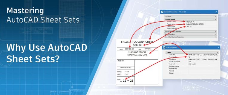
This post covers the reasons to employ Sheets, Sheet Sets, and the Sheet Set Manager in Phases of adoption or implementation.
The post is part of an on-going series by R.K. McSwain and Autodesk's Heidi Hewett.
Read the Post
This post is by R.K. McSwain who writes the CAD Panacea blog.
From the offical AutoCAD Blog
You can download the free Mastering AutoCAD Sheets Set ebook